One of the worst heat waves on record to hit the Pacific Northwest and British Columbia is underway, with temperatures soaring into the triple digits Saturday before reaching unprecedented levels Sunday and Monday.
Why it matters: Extreme heat events are dangerous to public health, with heat ranking as the nation’s top weather-related killer annually. In addition, extreme heat events such as this one are a clear manifestation of human-caused climate change, according to numerous peer reviewed studies.
- This heat wave will be a prolonged event with little overnight relief, and will affect cities where relatively few people have air conditioning, such as Seattle.
Driving the news: A highly unusual weather pattern is in place over the Pacific Northwest, with a record-strong high-pressure area aloft — known as a “heat dome” — parked over the region and intensifying through Monday.
- This heat dome is projected to yield temperature departures from average between 25°F and 45°F across multiple states and British Columbia.
- This heat, combined with a worsening drought, will raise the risk of wildfires across multiple Western states.
- It will also cause power demand to spike at a time when hydropower resources are lower than usual due to drought conditions.
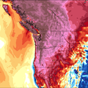
By the numbers: Virtually all of Oregon and Washington, plus portions of California, Idaho, Nevada and Montana, are under excessive heat watches and warnings. This is also the case in downtown Portland and Seattle.
- Portland, Oregon, is forecast to equal or break its all-time high temperature record three days in a row starting Saturday, with a high peaking at at 111°F on Sunday. Its previous all-time high stands at 107°F.
- In Seattle, the National Weather Service (NWS) predicts a high of 93°F on Saturday, 103°F on Sunday, and 108°F Monday. Sunday night’s overnight low is forecast to remain close to 80°F.
- Seattle’s all-time high temperature record is 103°F, and the city has only seen three 100-degree days in its history.
- Medford, Oregon and Spokane, Washington, are also predicted to shatter their all-time high temperature records by a few degrees.
- The heat will be most intense in inland areas of Washington and Oregon. There, temperatures are forecast to soar to between 100°F and 115°F Saturday through Tuesday, and remain extremely hot through much of next week.
- Canada will also see extreme heat, and it’s possible the country’s all-time high temperature record of 113°F (45°C) will be equaled or eclipsed.
How it works: One of the reasons the Pacific Northwest will get so hot is the center of the heat dome will be parked to the north-northeast of the region for several days.
- Due to the clockwise flow of air around the high, this will produce surges of air moving from high-to-lower elevation areas in Idaho, Washington and Oregon.
- When air sinks, such as when it moves out of mountainous regions and into valleys, it compresses, increasing temperatures and getting drier in the process.
Context: Studies have shown that severe heat events such as this one are now on average about 3°F to 5°F hotter than they would without the many decades of emissions of greenhouse gases from fossil fuel burning, deforestation and other human activities.
- However, this may understate climate change’s influence, since warming may also be altering weather patterns in a way that makes strong heat domes more common and prolonged.
- Some recent studies have shown that certain extreme heat events could not have occurred without the added boost from human-caused warming.
What they’re saying: National Weather Service (NWS) forecasters in Seattle said Friday they “have never seen Pacific Northwest data like this.” A weather balloon launched Friday afternoon found the freezing level in the atmosphere was at 18,000 feet high.
- Such high freezing levels have prompted the NWS and Environment Canada to warn of high levels of glacial melt runoff and snowmelt in higher elevations, including the slopes of Mount Rainier, Washington.
- “In my 22 years at this office, I’ve never seen anything that high,” an NWS forecasters wrote.
- The NWS, which is typically cautious in its public word choices, is not holding back this time around.
- “In short, heat of this magnitude has very rarely (if ever) been felt throughout this region, especially this early into the summer season,” the NWS’ Weather Prediction Center wrote Saturday.
- Agency social media accounts have also been relaying hot weather safety tips and directing people to cooling shelters.
Source: https://www.axios.com/pacific-northwest-heat-dome-25-million-records-bd910518-97ab-4834-85cd-c2941a99827e.html
Droolin’ Dog sniffed out this story and shared it with you.
The Article Was Written/Published By: Andrew Freedman
! #Headlines, #Axios, #ClimateChange, #Environment, #HeatWave, #Newsfeed, #Science, #ThePlanet, #Weather, drought, #Health, #News, #WorldNews
No comments:
Post a Comment